References
Working reference material for the Entangled at a Distance universe: traffic models, maps, and infrastructure. Open a section to explore it; models stay paused until opened.
Solar Traffic Model, the Sol corridor from cycler era to story present
Real Kepler orbits and era-correct transfers: chemical-era launch windows are minimum-energy Lambert solutions from a porkchop scan, exactly how real launch dates are chosen (Earth-Mars every 2.1 years, 8-9 month transits); torch ships fly 0.02 g flip-and-burn tracks directly between Earth and Mars once the first one enters service. The model pauses automatically at story present (SFUT 500); press Play to continue beyond it. Scroll to zoom, drag to pan.
Full disclosure: this simulator is AI-built to the creator's specifications, a rare and deliberate exception to this project's no-AI-content rule. See the exceptions list in the AI disclaimer.
Trip durations
MMS berths
Hover a bar for its ship and stay; click it to select that ship.
Yearly statistics
Dispatch rules: (1) there are windows to and from each location, Earth and Mars direct always, and via MMS once it is operational; (2) new ships only get created on Earth, only when a window from Earth fires and there isn't already one parked there; (3) when a window from the ship's location to that ship's destination opens, all ships that can use that window do use that window; (4) then they wait for their next window, from where each is to where it's going; (5) on a looping path that repeats, going back and forth between Earth and Mars via the next available window of either direct or via MMS; (6) destinations have a max capacity and only that many may be sent to a destination at one time: Earth infinite, Mars 15, MMS 5; a departure books a space out for its projected stay (a ship leaving Earth books every stop on its way back to Earth) and anything wanting to stop there checks for an available spot on its projected stay; Earth never builds more than one ship per window; (7) if waiting for a direct trip window would arrive at its destination before the MMS one would (with its added wait), that ship waits for the faster trip and skips the MMS window; (8) skipped windows don't build ships. MMS construction: a year after the Nokomis loss MMS construction starts and 4 years later it's fully operational; MMS shows up in the model from the start, with some ships going to and from it and Earth until it's finished (early use of MMS windows, only to and from Earth, with non-torch ships adding to the fleet). Torch ships: the first torch drive ship goes into service half way through MMS construction, then when SLS gets to full steam on He-3 production, every new ship from that point on is a torch; torch ships don't use MMS and leave as soon as they are ready, one a year at first and then every 6 months when He-3 has been producing steadily for a little while. The cargo cycler rides a permanent Earth-Mars cycling orbit; unmanned crates boost straight up to meet it at each planetary pass and drop straight down at the destination, no crewed ship needed: serviced, then 30 years of automated operation, then retired. Construction dates flagged in the log are working estimates while the codex chronology is reconciled.
Two systems on one scale, Sol beside Uinamn
Sol and the Uinamn system drawn to one shared scale, then Earth and the Moon beside Uinamn and its two moons. Every value is a ruled number or computed from one; the list under the panels says which. One clock runs both panels, in Earth days, cycles and Uinamn days. Use the zoom to look from the inner orbits out to 3.6 AU.
Full disclosure: this comparison is AI-built to the creator's specifications, a rare and deliberate exception to this project's no-AI-content rule. See the exceptions list in the AI disclaimer.
The two systems, one AU scale
Earth and the Moon beside Uinamn and its moons, one kilometre scale
Starting positions are arbitrary, not canon. Uinamn's worlds and moons are drawn on circles seen from above. Uinamn's eccentricity is ruled (~0.02) but not the orientation of its orbit, so it is drawn as a circle; the scorched world's and the giant's eccentricities, and Namnauro's tilt and eccentricity, are still open. In the AU panel the stars are enlarged at their true size ratio and the planets are markers. In the kilometre panel Earth, the Moon, Uinamn, Namnauro and Namnubis are drawn at true scale (anything under 3 pixels is shown at 3). The scission end's distance from Uinamn is open, so its marker shows only that it sits beside the planet.
Values used
- Star: K5V orange dwarf: 0.69 solar masses, 0.72 solar radii, 4,410 K, 16% of the Sun's light (ruled, ledger 280)
- Earth-level light: 0.40 AU from the star (Sol: 1 AU) (derived from the star's light)
- Scorched world: ~0.08 AU; year 9.95 Earth days (distance ruled; year derived by Kepler at 0.69 solar masses)
- Uinamn: 0.3997 AU; year 111.11 Earth days = 96 cycles = 38.4 Uinamn days (year ruled; distance derived from it, the record's 0.4 AU)
- Uinamn's day: 2.5 cycles (69.4 Earth hours) (ruled, ledger 280)
- Uinamn's size: diameter ~16,400 km, 1.63 Earth masses (ruled, ledger 280)
- Gas giant: ~1.5 AU; year 807.8 Earth days (distance ruled; year derived by Kepler)
- Consumed icy world: ~3 AU, orbit only (ruled: consumed to cut the bridge to Sol)
- Namnauro: 4.5 cycles (5.21 Earth days); 149,370 km (period ruled; radius derived from it, the record's ~150,000 km)
- Namnubis: 12.5 cycles = 5 Uinamn days (14.47 Earth days); 295,163 km (period ruled; radius derived from it, the record's ~295,000 km)
- Namnauro's size: radius ~1,360 km today, about the Moon's mass, surface gravity 0.29 g, in Uinamn's sky about 2 times the width of our full Moon; originally ~1,800 km and ~2.5 Moon masses, 57% of it mined outside-in (ruled, ledger 280)
- Namnauro's surface: a honeycomb of hexagonal excavation cells: iron walls up to ~25 km tall, the deepest shafts ~50 to 100 km at the last working face (ruled, ledger 280)
- Namnubis's structure: a hollow vault: a thin shell ~1,000 km in radius, its iron-ore wall ~40 km thick (also the gamma-ray shield), a vacuum gap, and a small antimatter hoard held at the centre; ~5% of the Moon's mass (ruled, ledger 280)
- Tides: against the Moon's pull on Earth's oceans: Namnauro ~18 times (~42 times before the mining), the star ~5 times, Namnubis ~0.1 times (ruled, ledger 280)
- Long tide cycle: ~8.3 Earth years (~27 Uinamn years, ~2,600 cycles), the precession of Namnauro's tilted orbit, set almost entirely by the star's pull (ruled, ledger 280)
- Uinamn's seasons: axial tilt ~7 degrees, orbital eccentricity ~0.02: seasons of about 28 Earth days (~24 cycles, ~10 Uinamn days), permanent polar ice (ruled, ledger 280)
- Synchronous orbit: 100,944 km (derived: an orbit as long as Uinamn's day)
- Uinamn's reach: 796,650 km (derived: the Hill radius, the record's ~800,000 km)
- Stable-moon limit: 398,325 km (derived: half the reach, the outer edge for long-lived prograde moons)
- Scission end: within Uinamn's reach, travelling with the planet (ruled; its exact distance is open, so the marker's spot on the kilometre scale is illustrative)
- MMS: 1.25 AU (provisional: its orbit and direction are still open)
Tharsis Industrial Corridor, story sites on real Mars topography
NASA MOLA colorized topography (public domain, Mercator). First the whole planet for scale, then the corridor in detail. Bright markers are story infrastructure; † marks placements fixed by canon description rather than surveyed coordinates.
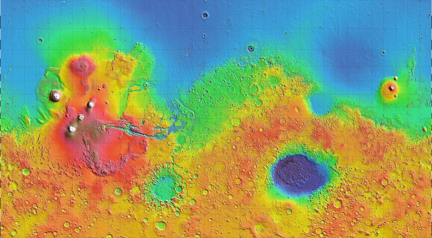
Global context, 70N to 70S: the corridor (outlined) spans roughly a quarter of the western hemisphere. The deep basin on the far side is Hellas Planitia, the largest visible impact structure on Mars.
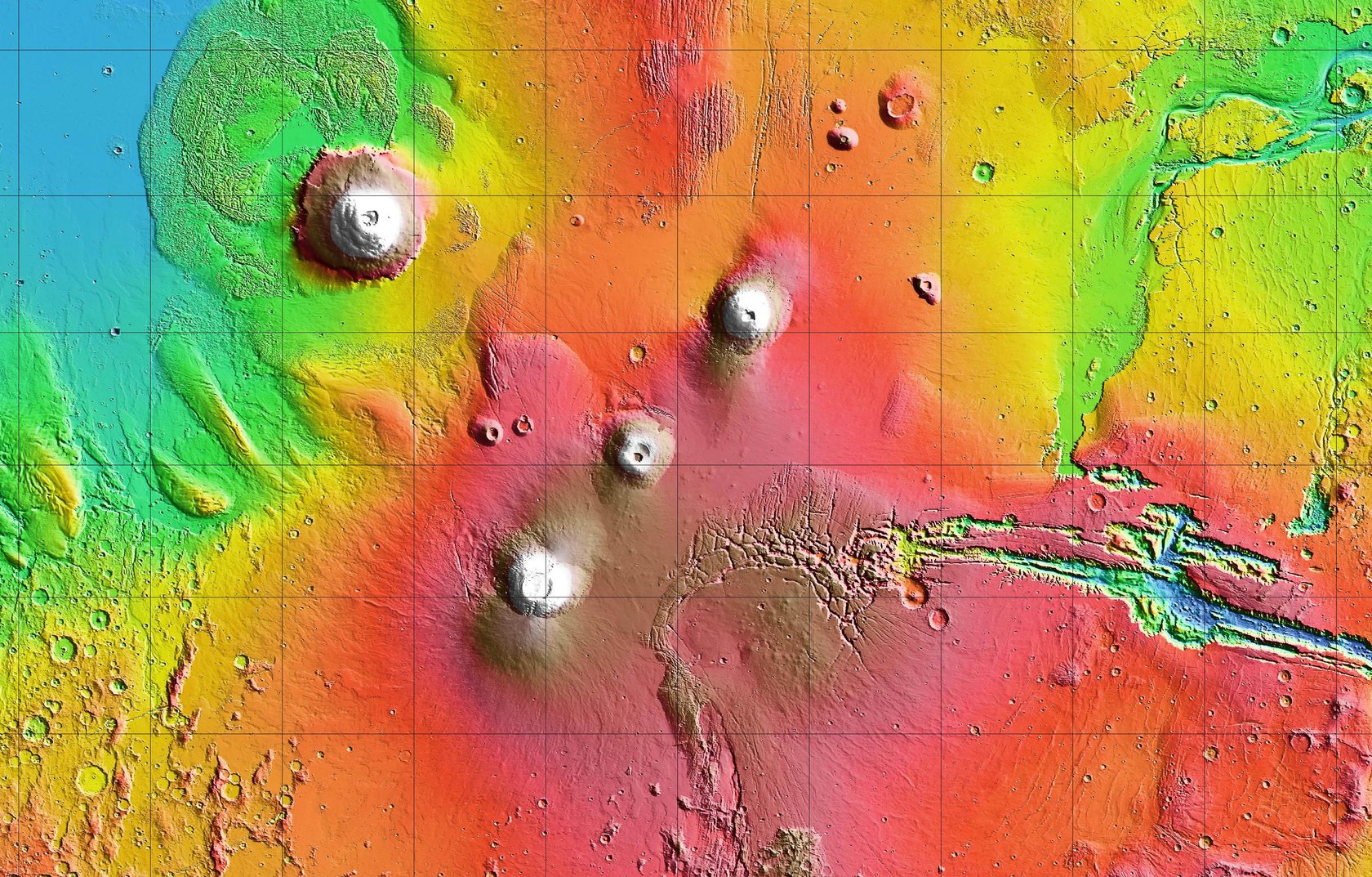
Two rail lines cross at the Pavonis Mons junction (white ring); the canyon line stays inside the deep trench floors: Oudemans into the Ius trench, east through Ius Hub to the Melas basin, where the Candor leg forks north into Candor Chasma and the main line continues down the Coprates neck to Coprates Hub. Measured: Noctis station to Oudemans ~590 km; Oudemans to Coprates Hub ~1,550 km; Candor leg from the fork ~160 km. Hub placements owner-approved; coordinates still nudgeable. Routing between anchors is drawn to plausible grade contours, not surveyed. Base map: NASA / JPL / GSFC Mars Orbiter Laser Altimeter, public domain.
SFUT to Earth time, the decimal clock at a glance
Space Faring Universal Time keeps the second and rebuilds everything above it in clean powers of ten: 100 seconds, then 100 Hundredths, then 10 Tenths, 10 Cycles, 10 Dex. Each row pairs an SFUT unit with the Earth unit whose job it does; the bars show their true relative lengths.
Disclosure: this chart is AI-built to the creator's numbers. See the exceptions list in the AI disclaimer.
The pattern to keep: a Cycle runs almost four hours longer than an Earth day, while an SFUT Year is exactly ten million seconds, a touch under a third of an Earth year. Timestamps read Year.Dex.Cycle : Tenth.Hundredth.Second, counted from the SFUT epoch, and every conversion runs through seconds, the one unit both clocks share.
TIDR in pictures, the framework's own explanatory imagery drawn out
The Time Interaction Density Reality framework explains itself through concrete imagery: light bending into water, walking through rain, threads pulled toward a slit. These diagrams draw exactly that imagery, nothing beyond what the codex describes.
Full disclosure: these diagrams are AI-drawn to the creator's specifications, and they are explicitly temporary placeholders: each one is slated to be replaced by a human-produced illustration. See the exceptions list in the AI disclaimer.
The codex is exact about this one: gravity is not a pull, it is refraction. The edge of a moving wavefront nearer a mass crosses more interactions and effectively slows, the far edge runs freer, and the whole path curves toward the dense region. The inset is the same mechanism at desk scale: light bending as it enters water.
Drops stand in for potential interactions filling the medium. Stand still and they arrive at the ordinary rate. Move, and each subjective moment sweeps through more of them. At light speed a traveler would have to process every drop at once, which is why nothing with mass gets there: the limit is built into how matter sits in the medium, not into engine design.
A directional slit cut into the medium, shown the way the codex describes its grid view: stretched lines converging on each puckered opening, tension holding the lips shut. There is no medium inside the slit, so there is nothing to cross; the far end is simply the next point on the path. The stretched edges run fast, the interior takes no time at all, and an approach at the wrong angle or too little speed slides off along the tension gradient instead of entering.
Before the universe there was only the Infinite, a boundless field of chaotic energy. The Split set off a crystallization: energy converting into matter and antimatter at once, kept apart by a new boundary layer, the medium. The front is still advancing today, and because that growth can never run backward, it hands every interaction inside a built-in direction: the arrow of time.
Why collapse starts slow and finishes fast. Every particle a cloud captures raises its interaction density, which bends passing paths harder, which captures more particles. The mechanism that creates gravity strengthens itself as it works, until the gradient is steep enough to hold moons in orbit. Panel by panel: barely bent paths, then a lean, then a spiral, then a world.